Utilization of Seismic Data as a Tsunami Vulnerability Review
DOI:
https://doi.org/10.12928/irip.v5i2.6706Keywords:
Bathymetry, Flores Sea, Run-Up, Tsunami, Vulnerability LevelAbstract
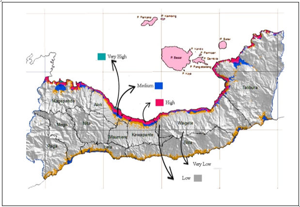
This study aimed to analyze seismic data, which is then made into an infographic to map the level of tsunami hazard in the Sikka District. The research was carried out in Sikka District, East Nusa Tenggara, located between 121°55'40''-122°41'30'' east longitude and 08°22'-08°50' south latitude. The data source comes from the IRIS Earthquake Browser, and the analysis stage was carried out in two phases. The first analysis used seismic data analysis, and EQ Energy used IRIS (Incorporated Research Institutions for Seismology) data. Meanwhile, the second analysis maps the tsunami risk by determining the tsunami hazard in areas with the potential for a tsunami. Based on the analysis of seismicity data showed that Sikka District has the potential for an earthquake accompanied by a tsunami. In contrast, the results of the EQ Energy analysis caused by the December 14, 2021 earthquake were known as the value of Ehf = 6.46 × 10¹⁴ J and EBB = 5.48 × 10¹⁵ J. The analysis of the level of tsunami susceptibility based on the tsunami run-up height in Sikka District showed that the northern coastal area of Flores had various potentials, where the highest vulnerability level was in the Alok subdistrict and parts of Talibura. Meanwhile, the area with the lowest potential was the Kewapante subdistrict.
References
H. Kurnio, T. Naibaho, and C. Purwanto, “Review of Submarine Landslides in the Eastern Indonesia Region,” Bull. Mar. Geol., vol. 34, no. 2, pp. 63–76, Dec. 2019, https://doi.org/10.32693/bomg.34.2.2019.618.
I. R. Pranantyo, M. Heidarzadeh, and P. R. Cummins, “Complex Tsunami Hazards in Eastern Indonesia from Seismic and Non-Seismic Sources: Deterministic Modelling Based on Historical and Modern Data,” Geosci. Lett., vol. 8, no. 1, p. 20, Dec. 2021, https://doi.org/10.1186/s40562-021-00190-y.
K. Sinki, Y. Fujii, and B. Shibazaki, “Numerical Simulations of the 1992 Flores Tsunami,” 2021. [Online]. Available: https://iisee.kenken.go.jp/syndb/data/20211209487648b2.pdf.
R. Maneno, B. J. Sentosa, and G. Rachman, “Relocation of Earthquake Hypocenter in the Flores Region Using Hypo71,” IPTEK J. Eng., vol. 5, no. 2, pp. 33–37, May 2019, https://doi.org/10.12962/j23378557.v5i2.a5024.
A. Muhammad, K. Goda, N. A. Alexander, W. Kongko, and A. Muhari, “Tsunami Evacuation Plans for Future Megathrust Earthquakes in Padang, Indonesia, Considering Stochastic Earthquake Scenarios,” Nat. Hazards Earth Syst. Sci., vol. 17, no. 12, pp. 2245–2270, Dec. 2017, https://doi.org/10.5194/nhess-17-2245-2017.
I. E. Mulia, S. Watada, T. Ho, K. Satake, Y. Wang, and A. Aditiya, “Simulation of the 2018 Tsunami Due to the Flank Failure of Anak Krakatau Volcano and Implication for Future Observing Systems,” Geophys. Res. Lett., vol. 47, no. 14, pp. 1–9, Jul. 2020, https://doi.org/10.1029/2020GL087334.
R. P. Felix, J. A. Hubbard, K. E. Bradley, K. H. Lythgoe, L. Li, and A. D. Switzer, “Tsunami Hazard in Lombok and Bali, Indonesia, Due to the Flores Back-arc Thrust,” Nat. Hazards Earth Syst. Sci., vol. 22, no. 5, pp. 1665–1682, May 2022, https://doi.org/10.5194/nhess-22-1665-2022.
A. Koulali et al., “Crustal Strain Partitioning and the Associated Earthquake Hazard in the Eastern Sunda‐Banda Arc,” Geophys. Res. Lett., vol. 43, no. 5, pp. 1943–1949, Mar. 2016, https://doi.org/10.1002/2016GL067941.
L. Handayani, “Seismic Hazard Analysis of Maumere, Flores: a Review of the Earthquake Sources,” 2020, https://doi.org/10.4108/eai.12-10-2019.2296247.
E. A. Okal, “Twenty-Five Years of Progress in the Science of ‘Geological’ Tsunamis Following the 1992 Nicaragua and Flores Events,” Pure Appl. Geophys., vol. 176, no. 7, pp. 2771–2793, Jul. 2019, https://doi.org/10.1007/s00024-019-02244-x.
I. R. Pranantyo and P. R. Cummins, “Multi-Data-Type Source Estimation for the 1992 Flores Earthquake and Tsunami,” Pure Appl. Geophys., vol. 176, no. 7, pp. 2969–2983, Jul. 2019, https://doi.org/10.1007/s00024-018-2078-4.
K. O. Kim, D. C. Kim, J.-H. Yuk, E. Pelinovsky, and B. H. Choi, “Extreme Tsunami Inundation at Babi Island due to Flores Earthquake Induced Tsunami in 1992,” Ocean Polar Res., vol. 37, no. 2, pp. 91–105, Jun. 2015, https://doi.org/10.4217/OPR.2015.37.2.091.
A. M. Julius and Daryono, “Overview of 1990s Deadly Tsunamis in Indonesia,” E3S Web Conf., vol. 331, p. 07001, Dec. 2021, https://doi.org/10.1051/e3sconf/202133107001.
K. Minoura, F. Imamura, T. Takahashi, and N. Shuto, “Sequence of Sedimentation Processes Caused by the 1992 Flores Tsunami: Evidence from Babi Island,” Geology, vol. 25, no. 6, pp. 523–526, 1997, https://doi.org/10.1130/0091-7613(1997)025<0523:SOSPCB>2.3.CO;2.
U. Kânoğlu, Y. Tanioka, E. A. Okal, M. A. Baptista, and A. B. Rabinovich, “Introduction to ‘Twenty Five Years of Modern Tsunami Science Following the 1992 Nicaragua and Flores Island Tsunamis, Volume II,’” Pure Appl. Geophys., vol. 177, no. 3, pp. 1183–1191, Mar. 2020, https://doi.org/10.1007/s00024-020-02451-x.
N. Cabral, “Revision of the Azorean Catalogue of Tsunamis,” Geol. Soc. London, Spec. Publ., vol. 501, no. 1, pp. 301–325, Jan. 2021, https://doi.org/10.1144/SP501-2019-107.
E. Sengaji and B. Nababan, “Pemetaan Tingkat Resiko Tsunami di kabupaten Sikka, Nusa Tenggara Timur,” J. Ilmu dan Teknol. Kelaut. Trop., vol. 1, no. 1, pp. 48–61, Jul. 2009, https://doi.org/10.29244/jitkt.v1i1.7938.
Badan Geologi, “Analisis Geologi Kejadian Gempa Bumi Merusak Di Laut Flores, Tanggal 14 Desember 2021,” Kementerian Energi dan Sumber Daya Mineral, 2021. https://vsi.esdm.go.id/index.php/gempabumi-a-tsunami/kejadian-gempabumi-a-tsunami/3868-analisis-geologi-kejadian-gempa-bumi-merusak-di-laut-flores-tanggal-14-desember-2021.
P. Supendi et al., “The Kalaotoa Fault: A Newly Identified Fault that Generated the Mw 7.3 Flores Sea Earthquake,” Seism. Rec., vol. 2, no. 3, pp. 176–185, Jul. 2022, https://doi.org/10.1785/0320220015.
D. A. Wiens, “Source and Aftershock Properties of the 1996 Flores Sea Deep Earthquake,” Geophys. Res. Lett., vol. 25, no. 6, pp. 781–784, Mar. 1998, https://doi.org/10.1029/98GL00417.
S. Goes, L. Ruff, and N. Winslow, “The Complex Rupture Process of the 1996 Deep Flores, Indonesia Earthquake (Mw 7.9) from Teleseismic P-waves,” Geophys. Res. Lett., vol. 24, no. 11, pp. 1295–1298, Jun. 1997, https://doi.org/10.1029/97GL01245.
A. K. Maimuna, A. F. Miftakhunnisa, and Y. A. Segoro, “Pemodelan Inversi 3 Dimensi untuk Identifikasi Dugaan Keberadaan Sesar menggunakan Data Anomali Gaya Berat di Laut Flores (Studi Kasus Gempa Flores 14 Desember 2021),” Prog. J. Geofis., vol. 1, no. 1, pp. 55–62, 2022, [Online]. Available: https://jurnal.stmkg.ac.id/index.php/pjg/article/view/260.
T. A. P. Setiadi, “Relokasi Gempabumi Teleseismic Double-Difference di Wilayah Bali – Nusa Tenggara dengan Model Kecepeatan 3D,” J. Lingkung. dan Bencana Geol., vol. 9, no. 1, pp. 45–52, Apr. 2018, https://doi.org/10.34126/jlbg.v9i1.149.
K. Nisa, L. Ambarwati, and T. Murdiyanto, “Simulasi Penjalaran Gelombang Tsunami Menggunakan Metode Optimal Time Stepping,” JMT J. Mat. dan Terap., vol. 3, no. 1, pp. 10–19, Feb. 2021, https://doi.org/10.21009/jmt.3.1.2.
P. Tandel, H. Patel, and T. Patel, “Tsunami Wave Propagation Model: A Fractional Approach,” J. Ocean Eng. Sci., vol. 7, no. 6, pp. 509–520, Dec. 2022, https://doi.org/10.1016/j.joes.2021.10.004.
I. P. A. Suriajaya Maha Putra, K. N. Suarbawa, and I. G. A. Putra Adnyana, “Studi Mitigasi Bencana Tsunami Dengan Menentukan Run Up Dan Waktu Tiba Tsunami Daerah Banyuwangi,” Bul. Fis., vol. 23, no. 2, pp. 130–136, Sep. 2022, https://doi.org/10.24843/BF.2022.v23.i02.p08.
I. R. Pranantyo and P. R. Cummins, “The 1674 Ambon Tsunami: Extreme Run-Up Caused by an Earthquake-Triggered Landslide,” Pure Appl. Geophys., vol. 177, no. 3, pp. 1639–1657, Mar. 2020, https://doi.org/10.1007/s00024-019-02390-2.
P. Supendi et al., “Fate of Forearc Lithosphere at Arc‐Continent Collision Zones: Evidence From Local Earthquake Tomography of the Sunda‐Banda Arc Transition, Indonesia,” Geophys. Res. Lett., vol. 47, no. 6, p. e2019GL086472, Mar. 2020, https://doi.org/10.1029/2019GL086472.
U. Kânoğlu, Y. Tanioka, E. A. Okal, M. A. Baptista, and A. B. Rabinovich, “Introduction to ‘Twenty Five Years of Modern Tsunami Science Following the 1992 Nicaragua and Flores Island Tsunamis, Volume I,’” Pure Appl. Geophys., vol. 176, no. 7, pp. 2757–2769, Jul. 2019, https://doi.org/10.1007/s00024-019-02266-5.
G. L. Choy and J. L. Boatwright, “Global Patterns of Radiated Seismic Energy and Apparent Stress,” J. Geophys. Res. Solid Earth, vol. 100, no. B9, pp. 18205–18228, Sep. 1995, https://doi.org/10.1029/95JB01969.
M. A. Marfai et al., “Tsunami Hazard Mapping and Loss Estimation Using Geographic Information System in Drini Beach, Gunungkidul Coastal Area, Yogyakarta, Indonesia,” E3S Web Conf., vol. 76, p. 03010, Jan. 2019, https://doi.org/10.1051/e3sconf/20197603010.
Downloads
Published
Issue
Section
License
Copyright (c) 2022 Azmi Khusnani, Adi Jufriansah, Mulya Afriyanto

This work is licensed under a Creative Commons Attribution-ShareAlike 4.0 International License.
Authors who publish in IRiP agree to the following terms: Authors retain copyright and grant the IRiP right of first publication with the work simultaneously licensed under a Creative Commons Attribution License (CC BY-SA 4.0) that allows others to share (copy and redistribute the material in any medium or format) and adapt (remix, transform, and build upon the material) the work for any purpose, even commercially with an acknowledgment of the work's authorship and initial publication in IRiP. Authors are able to enter into separate, additional contractual arrangements for the non-exclusive distribution of the journal's published version of the work (e.g., post it to an institutional repository or publish it in a book), with an acknowledgment of its initial publication in IRiP. Authors are permitted and encouraged to post their work online (e.g., in institutional repositories or on their website) prior to and during the submission process, as it can lead to productive exchanges, as well as earlier and greater citation of published work (See The Effect of Open Access).